|
| at: |
Bankhead National Forest |
Data from USFS GIS
 show on map
 animate
Trail users:


Elevation Profile
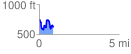
 0.894749 mi
 257.27 ft
 394.02 ft
 -136.75 ft
 8.34 %
GPX Downloads: Track Route
![]()
|
| at: |
Bankhead National Forest |
show on map
animate
0.894749 mi
257.27 ft
394.02 ft
-136.75 ft
8.34 %