|
| at: |
Bankhead National Forest |
Data from USFS GIS
 show on map
 animate
Trail users:


Elevation Profile
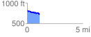
 1.112020 mi
 58.37 ft
 151.17 ft
 -92.81 ft
 2.57 %
GPX Downloads: Track Route
![]()
|
| at: |
Bankhead National Forest |
show on map
animate
1.112020 mi
58.37 ft
151.17 ft
-92.81 ft
2.57 %