|
| at: |
Bankhead National Forest |
Data from USFS GIS
 show on map
 animate
Trail users:


Elevation Profile
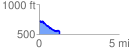
 1.297981 mi
 48.93 ft
 267.11 ft
 -218.18 ft
 3.90 %
GPX Downloads: Track Route
![]()
|
| at: |
Bankhead National Forest |
show on map
animate
1.297981 mi
48.93 ft
267.11 ft
-218.18 ft
3.90 %