|
| at: |
Talladega National Forest |
Data from USFS GIS
 show on map
 animate
Trail users:


Elevation Profile
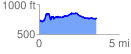
 3.609343 mi
 487.10 ft
 443.40 ft
 43.70 ft
 2.56 %
GPX Downloads: Track Route
![]()
|
| at: |
Talladega National Forest |
show on map
animate
3.609343 mi
487.10 ft
443.40 ft
43.70 ft
2.56 %