|
| at: |
Talladega National Forest |
Data from USFS GIS
 show on map
 animate
Trail users:


Elevation Profile
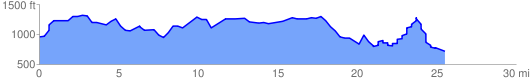
 25.983238 mi
 4097.23 ft
 4352.77 ft
 -255.54 ft
 3.17 %
GPX Downloads: Track Route
![]()
|
| at: |
Talladega National Forest |
show on map
animate
25.983238 mi
4097.23 ft
4352.77 ft
-255.54 ft
3.17 %