|
| at: |
Talladega National Forest |
Data from USFS GIS
 show on map
 animate
Trail users:


Elevation Profile
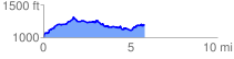
 5.820356 mi
 781.35 ft
 594.89 ft
 186.46 ft
 2.54 %
GPX Downloads: Track Route
![]()
|
| at: |
Talladega National Forest |
show on map
animate
5.820356 mi
781.35 ft
594.89 ft
186.46 ft
2.54 %