|
| at: |
Talladega National Forest |
Data from USFS GIS
 show on map
 animate
Trail users:


Elevation Profile
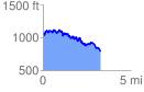
 3.379535 mi
 873.47 ft
 1099.24 ft
 -225.77 ft
 6.16 %
GPX Downloads: Track Route
![]()
|
| at: |
Talladega National Forest |
show on map
animate
3.379535 mi
873.47 ft
1099.24 ft
-225.77 ft
6.16 %