|
| at: |
Talladega National Forest |
Data from USFS GIS
 show on map
 animate
Trail users:


Elevation Profile
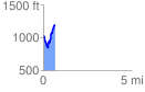
 0.657416 mi
 407.49 ft
 206.14 ft
 201.35 ft
 11.74 %
GPX Downloads: Track Route
![]()
|
| at: |
Talladega National Forest |
show on map
animate
0.657416 mi
407.49 ft
206.14 ft
201.35 ft
11.74 %