|
| at: |
Talladega National Forest |
Data from USFS GIS
 show on map
 animate
Trail users:


Elevation Profile
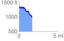
 1.659341 mi
 189.95 ft
 515.02 ft
 -325.08 ft
 5.88 %
GPX Downloads: Track Route
![]()
|
| at: |
Talladega National Forest |
show on map
animate
1.659341 mi
189.95 ft
515.02 ft
-325.08 ft
5.88 %