|
| at: |
Talladega National Forest |
Data from USFS GIS
 show on map
 animate
Trail users:


Elevation Profile
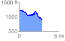
 2.922951 mi
 684.07 ft
 944.24 ft
 -260.17 ft
 6.12 %
GPX Downloads: Track Route
![]()
|
| at: |
Talladega National Forest |
show on map
animate
2.922951 mi
684.07 ft
944.24 ft
-260.17 ft
6.12 %