|
| at: |
Talladega National Forest |
Data from USFS GIS
 show on map
 animate
Trail users:


Elevation Profile
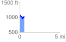
 0.566818 mi
 164.73 ft
 172.05 ft
 -7.32 ft
 5.75 %
GPX Downloads: Track Route
![]()
|
| at: |
Talladega National Forest |
show on map
animate
0.566818 mi
164.73 ft
172.05 ft
-7.32 ft
5.75 %