|
| at: |
Talladega National Forest |
Data from USFS GIS
 show on map
 animate
Trail users:


Elevation Profile
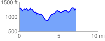
 7.334875 mi
 1604.62 ft
 1601.63 ft
 3.00 ft
 4.14 %
GPX Downloads: Track Route
![]()
|
| at: |
Talladega National Forest |
show on map
animate
7.334875 mi
1604.62 ft
1601.63 ft
3.00 ft
4.14 %