|
| at: |
Talladega National Forest |
Data from USFS GIS
 show on map
 animate
Trail users:


Elevation Profile
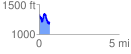
 0.675215 mi
 188.29 ft
 324.86 ft
 -136.57 ft
 9.11 %
GPX Downloads: Track Route
![]()
|
| at: |
Talladega National Forest |
show on map
animate
0.675215 mi
188.29 ft
324.86 ft
-136.57 ft
9.11 %