|
| at: |
Talladega National Forest |
Data from USFS GIS
 show on map
 animate
Trail users:


Elevation Profile
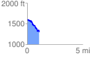
 1.085296 mi
 141.37 ft
 427.12 ft
 -285.75 ft
 7.45 %
GPX Downloads: Track Route
![]()
|
| at: |
Talladega National Forest |
show on map
animate
1.085296 mi
141.37 ft
427.12 ft
-285.75 ft
7.45 %