|
| at: |
Talladega National Forest |
Data from USFS GIS
 show on map
 animate
Trail users:


Elevation Profile
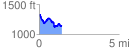
 1.427588 mi
 219.25 ft
 398.01 ft
 -178.76 ft
 5.28 %
GPX Downloads: Track Route
![]()
|
| at: |
Talladega National Forest |
show on map
animate
1.427588 mi
219.25 ft
398.01 ft
-178.76 ft
5.28 %