|
| at: |
Talladega National Forest |
Data from USFS GIS
 show on map
 animate
Trail users:


Elevation Profile
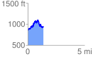
 1.375986 mi
 557.29 ft
 485.34 ft
 71.94 ft
 7.67 %
GPX Downloads: Track Route
![]()
|
| at: |
Talladega National Forest |
show on map
animate
1.375986 mi
557.29 ft
485.34 ft
71.94 ft
7.67 %