|
| at: |
Talladega National Forest |
Data from USFS GIS
 show on map
 animate
Trail users:


Elevation Profile
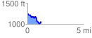
 1.215396 mi
 174.20 ft
 386.92 ft
 -212.72 ft
 6.03 %
GPX Downloads: Track Route
![]()
|
| at: |
Talladega National Forest |
show on map
animate
1.215396 mi
174.20 ft
386.92 ft
-212.72 ft
6.03 %