|
| at: |
Talladega National Forest |
Data from USFS GIS
 show on map
 animate
Trail users:


Elevation Profile
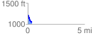
 0.368228 mi
 61.09 ft
 213.45 ft
 -152.36 ft
 10.98 %
GPX Downloads: Track Route
![]()
|
| at: |
Talladega National Forest |
show on map
animate
0.368228 mi
61.09 ft
213.45 ft
-152.36 ft
10.98 %