|
| at: |
Talladega National Forest |
Data from USFS GIS
 show on map
 animate
Trail users:


Elevation Profile
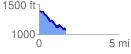
 1.665782 mi
 150.76 ft
 460.80 ft
 -310.05 ft
 5.24 %
GPX Downloads: Track Route
![]()
|
| at: |
Talladega National Forest |
show on map
animate
1.665782 mi
150.76 ft
460.80 ft
-310.05 ft
5.24 %