|
| at: |
Talladega National Forest |
Data from USFS GIS
 show on map
 animate
Trail users:


Elevation Profile
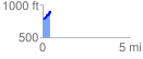
 0.449792 mi
 143.02 ft
 40.97 ft
 102.05 ft
 6.02 %
GPX Downloads: Track Route
![]()
|
| at: |
Talladega National Forest |
show on map
animate
0.449792 mi
143.02 ft
40.97 ft
102.05 ft
6.02 %