|
| at: |
Talladega National Forest |
Data from USFS GIS
 show on map
 animate
Trail users:


Elevation Profile
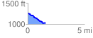
 1.564870 mi
 72.29 ft
 299.78 ft
 -227.49 ft
 3.63 %
GPX Downloads: Track Route
![]()
|
| at: |
Talladega National Forest |
show on map
animate
1.564870 mi
72.29 ft
299.78 ft
-227.49 ft
3.63 %