|
| at: |
Talladega National Forest |
Data from USFS GIS
 show on map
 animate
Trail users:


Elevation Profile
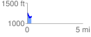
 0.399549 mi
 45.89 ft
 133.37 ft
 -87.49 ft
 6.32 %
GPX Downloads: Track Route
![]()
|
| at: |
Talladega National Forest |
show on map
animate
0.399549 mi
45.89 ft
133.37 ft
-87.49 ft
6.32 %