|
| at: |
Talladega National Forest |
Data from USFS GIS
 show on map
 animate
Trail users:


Elevation Profile
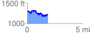
 1.876208 mi
 418.66 ft
 480.44 ft
 -61.78 ft
 4.85 %
GPX Downloads: Track Route
![]()
|
| at: |
Talladega National Forest |
show on map
animate
1.876208 mi
418.66 ft
480.44 ft
-61.78 ft
4.85 %