|
| at: |
Talladega National Forest |
Data from USFS GIS
 show on map
 animate
Trail users:


Elevation Profile
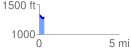
 0.306057 mi
 46.42 ft
 61.78 ft
 -15.36 ft
 3.82 %
GPX Downloads: Track Route
![]()
|
| at: |
Talladega National Forest |
show on map
animate
0.306057 mi
46.42 ft
61.78 ft
-15.36 ft
3.82 %