|
| at: |
Talladega National Forest |
Data from USFS GIS
 show on map
 animate
Trail users:


Elevation Profile
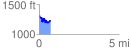
 0.713136 mi
 134.27 ft
 229.21 ft
 -94.95 ft
 6.09 %
GPX Downloads: Track Route
![]()
|
| at: |
Talladega National Forest |
show on map
animate
0.713136 mi
134.27 ft
229.21 ft
-94.95 ft
6.09 %