|
| at: |
Talladega National Forest |
Data from USFS GIS
 show on map
 animate
Trail users:


Elevation Profile
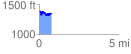
 0.773733 mi
 124.37 ft
 151.20 ft
 -26.83 ft
 3.70 %
GPX Downloads: Track Route
![]()
|
| at: |
Talladega National Forest |
show on map
animate
0.773733 mi
124.37 ft
151.20 ft
-26.83 ft
3.70 %