|
| at: |
Talladega National Forest |
Data from USFS GIS
 show on map
 animate
Trail users:


Elevation Profile
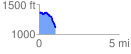
 1.040230 mi
 72.06 ft
 289.10 ft
 -217.04 ft
 5.26 %
GPX Downloads: Track Route
![]()
|
| at: |
Talladega National Forest |
show on map
animate
1.040230 mi
72.06 ft
289.10 ft
-217.04 ft
5.26 %