|
| at: |
Talladega National Forest |
Data from USFS GIS
 show on map
 animate
Trail users:


Elevation Profile
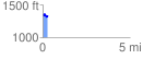
 0.293280 mi
 42.02 ft
 54.33 ft
 -12.30 ft
 3.51 %
GPX Downloads: Track Route
![]()
|
| at: |
Talladega National Forest |
show on map
animate
0.293280 mi
42.02 ft
54.33 ft
-12.30 ft
3.51 %