|
| at: |
Talladega National Forest |
Data from USFS GIS
 show on map
 animate
Trail users:


Elevation Profile
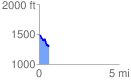
 0.642982 mi
 56.63 ft
 238.95 ft
 -182.32 ft
 7.04 %
GPX Downloads: Track Route
![]()
|
| at: |
Talladega National Forest |
show on map
animate
0.642982 mi
56.63 ft
238.95 ft
-182.32 ft
7.04 %