|
| at: |
Talladega National Forest |
Data from USFS GIS
 show on map
 animate
Trail users:


Elevation Profile
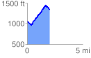
 2.038329 mi
 725.04 ft
 431.96 ft
 293.08 ft
 6.74 %
GPX Downloads: Track Route
![]()
|
| at: |
Talladega National Forest |
show on map
animate
2.038329 mi
725.04 ft
431.96 ft
293.08 ft
6.74 %