|
| at: |
Talladega National Forest |
Data from USFS GIS
 show on map
 animate
Trail users:


Elevation Profile
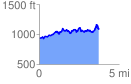
 3.764787 mi
 892.23 ft
 742.94 ft
 149.29 ft
 4.49 %
GPX Downloads: Track Route
![]()
|
| at: |
Talladega National Forest |
show on map
animate
3.764787 mi
892.23 ft
742.94 ft
149.29 ft
4.49 %