|
| at: |
Talladega National Forest |
Data from USFS GIS
 show on map
 animate
Trail users:


Elevation Profile
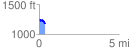
 0.380658 mi
 27.46 ft
 99.98 ft
 -72.52 ft
 4.97 %
GPX Downloads: Track Route
![]()
|
| at: |
Talladega National Forest |
show on map
animate
0.380658 mi
27.46 ft
99.98 ft
-72.52 ft
4.97 %