|
| at: |
Talladega National Forest |
Data from USFS GIS
 show on map
 animate
Trail users:


Elevation Profile
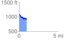
 0.983841 mi
 101.29 ft
 247.85 ft
 -146.56 ft
 4.77 %
GPX Downloads: Track Route
![]()
|
| at: |
Talladega National Forest |
show on map
animate
0.983841 mi
101.29 ft
247.85 ft
-146.56 ft
4.77 %