|
| at: |
Talladega National Forest |
Data from USFS GIS
 show on map
 animate
Trail users:


Elevation Profile
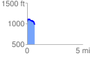
 0.720825 mi
 128.30 ft
 220.50 ft
 -92.21 ft
 5.79 %
GPX Downloads: Track Route
![]()
|
| at: |
Talladega National Forest |
show on map
animate
0.720825 mi
128.30 ft
220.50 ft
-92.21 ft
5.79 %