|
| at: |
Talladega National Forest |
Data from USFS GIS
 show on map
 animate
Trail users:


Elevation Profile
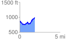
 1.889569 mi
 511.64 ft
 371.46 ft
 140.18 ft
 5.13 %
GPX Downloads: Track Route
![]()
|
| at: |
Talladega National Forest |
show on map
animate
1.889569 mi
511.64 ft
371.46 ft
140.18 ft
5.13 %