|
| at: |
Talladega National Forest |
Data from USFS GIS
 show on map
 animate
Trail users:


Elevation Profile
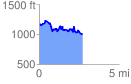
 2.734684 mi
 617.40 ft
 807.61 ft
 -190.20 ft
 5.59 %
GPX Downloads: Track Route
![]()
|
| at: |
Talladega National Forest |
show on map
animate
2.734684 mi
617.40 ft
807.61 ft
-190.20 ft
5.59 %