|
| at: |
Talladega National Forest |
Data from USFS GIS
 show on map
 animate
Trail users:


Elevation Profile
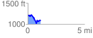
 1.142153 mi
 216.83 ft
 326.82 ft
 -109.99 ft
 5.42 %
GPX Downloads: Track Route
![]()
|
| at: |
Talladega National Forest |
show on map
animate
1.142153 mi
216.83 ft
326.82 ft
-109.99 ft
5.42 %