|
| at: |
Talladega National Forest |
Data from USFS GIS
 show on map
 animate
Trail users:


Elevation Profile
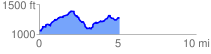
 5.209675 mi
 769.32 ft
 580.75 ft
 188.57 ft
 2.80 %
GPX Downloads: Track Route
![]()
|
| at: |
Talladega National Forest |
show on map
animate
5.209675 mi
769.32 ft
580.75 ft
188.57 ft
2.80 %