|
| at: |
Talladega National Forest |
Data from USFS GIS
 show on map
 animate
Trail users:


Elevation Profile
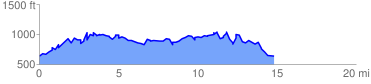
 15.037095 mi
 4238.44 ft
 4238.44 ft
 0.00 ft
 5.34 %
GPX Downloads: Track Route
![]()
|
| at: |
Talladega National Forest |
show on map
animate
15.037095 mi
4238.44 ft
4238.44 ft
0.00 ft
5.34 %