|
| at: |
Talladega National Forest |
Data from USFS GIS
 show on map
 animate
Trail users:


Elevation Profile
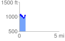
 0.764107 mi
 219.26 ft
 264.25 ft
 -44.98 ft
 6.55 %
GPX Downloads: Track Route
![]()
|
| at: |
Talladega National Forest |
show on map
animate
0.764107 mi
219.26 ft
264.25 ft
-44.98 ft
6.55 %