|
| at: |
Talladega National Forest |
Data from USFS GIS
 show on map
 animate
Trail users:


Elevation Profile
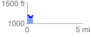
 0.545279 mi
 54.46 ft
 75.11 ft
 -20.65 ft
 2.61 %
GPX Downloads: Track Route
![]()
|
| at: |
Talladega National Forest |
show on map
animate
0.545279 mi
54.46 ft
75.11 ft
-20.65 ft
2.61 %