|
| at: |
Talladega National Forest |
Data from USFS GIS
 show on map
 animate
Trail users:


Elevation Profile
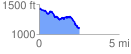
 2.531708 mi
 261.63 ft
 588.07 ft
 -326.44 ft
 4.40 %
GPX Downloads: Track Route
![]()
|
| at: |
Talladega National Forest |
show on map
animate
2.531708 mi
261.63 ft
588.07 ft
-326.44 ft
4.40 %