|
| at: |
Talladega National Forest |
Data from USFS GIS
 show on map
 animate
Trail users:


Elevation Profile
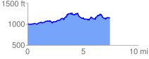
 7.502743 mi
 936.03 ft
 794.04 ft
 141.99 ft
 2.36 %
GPX Downloads: Track Route
![]()
|
| at: |
Talladega National Forest |
show on map
animate
7.502743 mi
936.03 ft
794.04 ft
141.99 ft
2.36 %