|
| at: |
Talladega National Forest |
Data from USFS GIS
 show on map
 animate
Trail users:


Elevation Profile
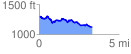
 3.355100 mi
 357.63 ft
 517.47 ft
 -159.84 ft
 2.92 %
GPX Downloads: Track Route
![]()
|
| at: |
Talladega National Forest |
show on map
animate
3.355100 mi
357.63 ft
517.47 ft
-159.84 ft
2.92 %