|
| at: |
Talladega National Forest |
Data from USFS GIS
 show on map
 animate
Trail users:


Elevation Profile
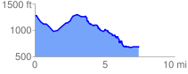
 7.511955 mi
 1138.23 ft
 1743.19 ft
 -604.95 ft
 4.39 %
GPX Downloads: Track Route
![]()
|
| at: |
Talladega National Forest |
show on map
animate
7.511955 mi
1138.23 ft
1743.19 ft
-604.95 ft
4.39 %