|
| at: |
Talladega National Forest |
Data from USFS GIS
 show on map
 animate
Trail users:


Elevation Profile
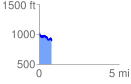
 0.797667 mi
 114.52 ft
 247.58 ft
 -133.05 ft
 5.88 %
GPX Downloads: Track Route
![]()
|
| at: |
Talladega National Forest |
show on map
animate
0.797667 mi
114.52 ft
247.58 ft
-133.05 ft
5.88 %