|
| at: |
Talladega National Forest |
Data from USFS GIS
 show on map
 animate
Trail users:


Elevation Profile
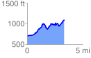
 3.370038 mi
 813.44 ft
 428.71 ft
 384.73 ft
 4.57 %
GPX Downloads: Track Route
![]()
|
| at: |
Talladega National Forest |
show on map
animate
3.370038 mi
813.44 ft
428.71 ft
384.73 ft
4.57 %