|
| at: |
Talladega National Forest |
Data from USFS GIS
 show on map
 animate
Trail users:


Elevation Profile
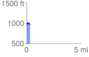
 0.304273 mi
 64.93 ft
 44.56 ft
 20.37 ft
 4.04 %
GPX Downloads: Track Route
![]()
|
| at: |
Talladega National Forest |
show on map
animate
0.304273 mi
64.93 ft
44.56 ft
20.37 ft
4.04 %