| at: |
Talladega National Forest |
Data from USFS GIS
 show on map
 animate
Trail users:


Elevation Profile
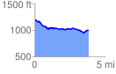
 3.836952 mi
 187.13 ft
 382.80 ft
 -195.67 ft
 1.89 %
GPX Downloads: Track Route
![]()
| at: |
Talladega National Forest |
show on map
animate
3.836952 mi
187.13 ft
382.80 ft
-195.67 ft
1.89 %