|
| at: |
Talladega National Forest |
Data from USFS GIS
 show on map
 animate
Trail users:


Elevation Profile
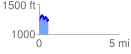
 0.594952 mi
 163.57 ft
 154.54 ft
 9.03 ft
 5.21 %
GPX Downloads: Track Route
![]()
|
| at: |
Talladega National Forest |
show on map
animate
0.594952 mi
163.57 ft
154.54 ft
9.03 ft
5.21 %